A combination of fog-trapping hollows, lorry-taxing gradients and several kilometres of single carriageway shoehorned between two stretches of dual carriageway, makes the A417 between Gloucester and Swindon a daunting prospect for drivers.
If this were not enough, unpredictable congestion frequently forces motorists onto narrow local roads criss-crossed by long-distance footpaths, putting ramblers in conflict with motorists. It’s easy to understand the case for the upgrade.
Although the road was identified as needing improvement more than 20 years ago, National Highways project director Steve Foxley believes it has taken this long to get to delivery stage because until now it was filed under ‘too difficult’.
“The scheme that we’re building is option 30,” he says, “and that probably tells you all you need to know about the process. It looked at everything from ‘can you tunnel through the Cotswolds?’ to the current scheme and everything in between.”
Many of the obstacles are related to the route’s location. It crosses an escarpment in the Cotswolds Area of Outstanding Natural Beauty and has increasingly become a short cut between the M5 and M4 motorways.

The topographical and traffic management challenges of improving highway gradients and doubling up lanes on a road that carries 40,000 vehicles per day were not to be taken lightly. However the obvious solution – creating a new route offline – was clearly a sensitive one in the context of the natural environment.
The consented scheme will nevertheless see the majority of the new 5.5km of highway built offline, with the existing alignment at Crickley Hill widened and the gradient improved. Although this hill currently has a crawler lane for slow vehicles, it is still fundamentally an unsegregated single carriageway road.
According to Foxley, ‘landscape-led design’ – as this scheme is labelled – aims to integrate the new road into the natural landscape. This includes introducing ecological design features such as habitat and wildlife crossings, linking and restoring hedgerows, creating woodland and planting locally important grassland, as well as providing new habitat for rare and protected wildlife.
For physical assets it means adapting the road alignment and location of structures to minimise their visual impact on the landscape, using locally appropriate materials for structures, and incorporating features that improve access and recreational opportunities.
Foxley explains: “At the top of the hill we are creating a deep cutting – the idea is that you won’t see the road at all. Elsewhere we follow the lie of the land where possible. We are planting a large number of trees, both semi-mature and saplings, to screen the road. And we’re building about 6.5km of drystone walls.”
The highway connections that currently serve local communities are being rationalised. New junctions are being built offline so local traffic can join the road safely, farm traffic can avoid it altogether and rat-running through villages can be eliminated.
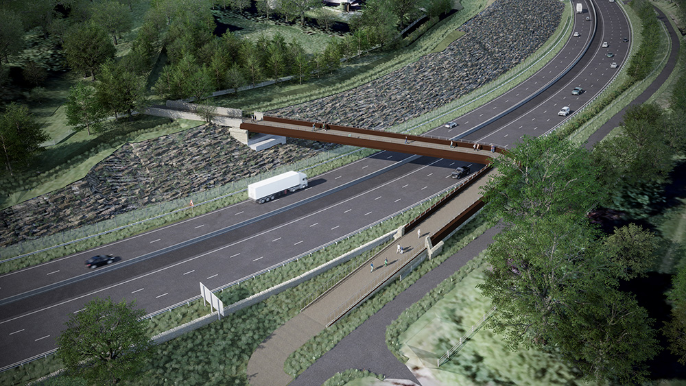
The biggest of the new overbridges will be dedicated to non-motorised traffic. This is an 8m-wide, 38m-long ‘green bridge’ allowing hikers on the long-distance Gloucestershire Way to cross the road safely for the first time and, at the same time, creating a wildlife corridor over the highway.

This is one of the many local walking routes that will be opened up by the construction of the scheme; just downhill a second footbridge will carry the Cotswolds Way safely over the highway.
The project includes an equestrian underpass (“in theory you can cross the road on a horse,” Foxley says doubtfully) as well as one for bats on the alignment of a stream along which they are known to hunt.
While some creatures are encouraged to traverse the route, measures have been included to divert others away – or at least to keep them out of the line of potential harm. A fence along the side of the road is designed to encourage owls to fly higher as they cross the road.
Some 2.5km of the existing road at the north end will be returned to a multi-use route for equestrians, hikers and cyclists while the southern section will be de-trunked into a 5m-wide local access road with passing places to allow farm traffic to negotiate it.
Initially the preferred bidder for the £460m contract was Taylor Woodrow, but Foxley reveals that National Highways was not able to agree terms and opted to seek a new partner. Taylor Woodrow’s proposal to reduce lane capacity during construction did not sit well with the client; Kier won favour with an alternative methodology that relies on contraflows and intense weekend closures, resourced for 24-hour working.
With environment in the spotlight, it is no surprise that the first year of delivery saw an enabling package focused on offsetting habitat loss, relocating more than 2,000 reptiles and several active badger setts, as well as accommodating a major archaeological dig (see The Construction Index, July 2023).
“We were moving adders, grass snakes, lizards, and slow worms,” recalls Kier construction manager Mark Sabbato. “We had set aside areas around the site that we could locate them to, but these were quickly filled up and so we had to move them to other sites in Gloucestershire, and even Shropshire and Herefordshire.
“It was a critical path item,” he adds. “We knew we had to get everything cleared by hibernation time last year otherwise we wouldn’t have been able to progress. We had around 50 ecologists on site 24 hours a day, monitoring and carrying out the work.”

The areas of the route that were of interest to archaeologists had already been identified before the contract was awarded, Sabbato explains: “They did an initial review in 2020 and knew where they wanted to focus.”
The early fieldwork unearthed artefacts including more than two dozen Roman coins, a number of Roman brooches and a rare figurine depicting Cupid as Hercules. The subsequent dig in 2023 uncovered an Iron Age enclosure thought to have been a hub for significant activities like feasting, a discovery that was featured on the BBC2 archaeology show Digging for Britain.
Sabbato says: “We had more than 100 archaeologists on site at the peak – we still have about 40 there but they should be finishing up in the next couple of months. We are still stripping topsoil, under a watching brief by the archaeologists.”
Earthmoving is currently the main activity on the site, he says, but while extensive excavation work is required and there are similarly significant areas of fill to achieve, overall the only material being brought in is the drainage layer.

“The material that we are excavating is an oolitic limestone and it is very soft,” says Sabbato. “It weathers and has lots of fines and silt in it, so we can’t use it for our drainage layer. All our 6C material is being brought in.”
Nevertheless the same material has other benefits, especially in terms of wet weather working, he admits. “The beauty of working in this rock material is that you can keep going a lot longer in bad weather; we’re not wading through clay and up to our axles in mud.
“But the nature of what we are digging out does mean that about two thirds of it has to be crushed, and that means extra handling.” Around 1.5 million cubic metres of material will be excavated in total, says Sabbato, and out of this some 350,000 cubic metres will be used to reduce the gradient on Crickley Hill from 10% to 8%.

The remainder of the material will be used at the new Shab Hill junction, which Sabbato describes as ‘the nerve-centre of the project’, and which provides links towards Oxford and access to the village of Birdlip.
Cuttings are up to 16m deep and ironically some of the finishing works are being delivered right at the start of the scheme. A drystone wall is being built along the alignment of one of these features – before excavation begins – to overcome the difficulty of accessing the site once the ground is removed.
Three of the four overbridges on the scheme will be concrete structures. As the largest of the four, the 38m-long Gloucestershire Way ‘green bridge’ is on the critical path, and Sabbato says that piling work for this crossing is currently under way with the reinforced concrete subcontractor due to start work imminently.
The others are not modest by any means – even the Stockwell Farm accommodation bridge has a width of 5.2m and is designed for use by combine harvesters – but they are offline of the existing highway so can be progressed without too much complication.
Meanwhile the Cotswold Way footbridge, which will be built of weathering steel, is intended to be assembled offline and moved into place using self-propelled modular transporters. The bridge will potentially be built right next to its permanent location but Sabbato admits he can only confirm the practicality of this plan when land clearance has progressed further.
Completion of the new route and the reconfigured local network is officially scheduled for February 2027; although the notice to proceed was granted in December 2023, work didn’t start in earnest until March this year. “The challenge is on to get it done quicker,” reveals Foxley, “though that will depend on how wet it is this year. Provisionally we are looking to finish late 2026 but there’s a few months of float on the back end to manage the weather.”
Sabbato is more gung-ho: “In the end we have got an open-to-traffic date and we’ve got to meet that. We have to resource the job to suit the schedule, and although we’re not quite where I would like us to be at the moment, we’re not far away,” he says.
Attention will turn to landscaping of the old road once the new alignment is open to traffic, finding a use for some of the surplus of topsoil that the scheme will create in returning agricultural land to natural calcareous grassland. The former highway will then become a 3m-wide multi-use route for riders, hikers and bikers.

Got a story? Email news@theconstructionindex.co.uk